Intro to Satellite Sleuthing 101: Finding Haradh III
Posted by JoulesBurn on February 29, 2008 - 11:10am

This project began early last year with a crude effort to map out Saudi oil fields using Google Maps. I soon discovered that recent releases of Google Earth facilitated this at a much higher level. After being inspired by the work of Stuart Staniford, Euan Mearns, and other TOD contributers on Ghawar, I persisted and was soon sucked in beyond the point of no return. This finally resulted in the creation of Satellite o'er the Desert where I will try to relieve the backlog of what I have learned (and am continuing to learn). It is planned that many articles will be posted here as well for discussion.
Getting Started
The first few entries at SOTD present an introduction to using Google Earth to study oil fields. Rather than repeat all of that here, I will just suggest reading the following:
Some people (such as my niece) like to work on 500+ piece jigsaw puzzles where you know what the end result will look like and the pieces almost all look the same. I can only take so much of that, but the Saudi oil is very much a puzzle with hints scattered across the internet. I don't think that many (even at Saudi Aramco) know what the picture really looks like. So, on with the fun!
Finding Haradh III
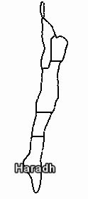 Haradh is the southernmost operational area of the Ghawar oil field, and Increment III represents the development of the bottom third of the area. This project was completed and production brought online in early 2006, although the field wasn't producing at the planned output capacity of 300,000 barrels of oil per day until mid year. The infrastructure put in place includes 32 maximum reservoir contact (MRC) wells (each with multiple horizontal laterals), 28 horizontal water injector wells, 12 observation wells, and a new gas-oil separation plant (GOSP).
What does Haradh III look like? There were some rather crude renditions being used in Saudi Aramco presentations for awhile, but they eventually decided to come clean with the article Haradh III: A Milestone for Smart Fields which included the following image:
This seems to be a fairly definitive representation. To see if this reflects how the field was actually laid out, we will use Google Earth to overlay this image over the satellite imagery for the tip of Haradh. Unfortunately, the imagery for most of that area was taken between May through November of 2004 as the project was just getting started. Fortunately, the water injectors on the east side lie in an area photographed in May 2006 and so we have an initial point of reference. Also, the Haradh III GOSP construction was far enough along in November 2004 that its location is clear as well. There are also low resolution DigitalGlobe preview images available dating to 2006-2007 which cover parts of Haradh. While it is not possible to make apriori identifications using these, they can be used for spotting changes indicative of new development by comparison with older high resolution images covering the same area.
Finding Putative Haradh III Wells
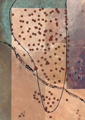
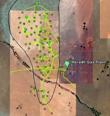
Another complication is that the area encompassed by this project is already full of wells, as shown in the left figure below. The field boundary is drawn based on its location relative to the wells in the paper by Stenger et. al. Assessing the Oil Water Contact in Haradh Arab-D (SPE 71339). Upon closer inspection, it is determined that over 80 of these are gas wells drilled down into the Khuff formation deep beneath the Arab-D oil reservoir. These can be clearly distinguished from oil wells as discussed here. Shown below right are identified gas wells along with the network of manifolds and pipelines which feed the gas into the Haradh Gas Plant.
 |
|
One other curious observation regarding the gas wells is that they are almost invariably oriented as shown below (north is towards the top), even when it results in a rather contorted path for the pipeline.
It Seems To Fit
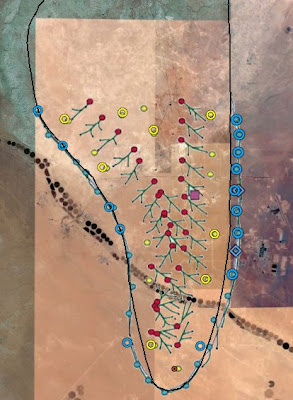
With the gas wells identified, it becomes easier to ignore these while adjusting the dimensions and position of the overlay to match putative Haradh III wells. The the result of this process is shown below at left. The published image was found to be stretched horizontally by about 22% from the true aspect. Existing wells or well sites are identified with large circles (blue for injectors, yellow for observation wells). Two drilling rigs are observed (May 2006) at injector sites on the eastern flank. It is clear that several wells present in 2004 were either targeted for or reused as observation wells for Haradh III. Also, six water injection wells were seemingly present by mid 2004. This conflicts with this report which indicates that development didn't start until Feb. 2005. However, an earlier well layout map shown in a Feb. 2004 CSIS presentation by Nansen Saleri (former reservoir czar for Saudi Aramco) suggests that several wells around the periphery were put in place by then and that these were distinct from the 28 planned for 2005-2006.
 |
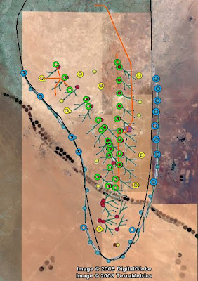 |
Using low-resolution DigitalGlobe preview images as overlays as described earlier, we can try to confirm locations for the Haradh III producers. Tentative confirmations (how's that for a hedge) are indicated with green circles in the figure above at right. 26 of the 32 producers were accounted for. Recent imagery covering those at the southern tip was not available. Also shown (with red lines) are some new pipelines that were found, including a connection line from the new GOSP III to GOSP II (located just up into the low resolution coverage area). This is most likely used to transport water for injection in Haradh III. An additional well was identified at the right top, although a pipeline also visible in the low resolution 2006 photo shows that this connects with a manifold for the Haradh II increment. This highlights the point that, while boundaries can be drawn on a map separating development increments, there is really no geological boundary between them.
It is curious that the May 2006 drilling date for the two water injectors comes several months after production completion was announced. Also, there is this report which describes MRC well Haradh-1425 being drilled in April 2006. 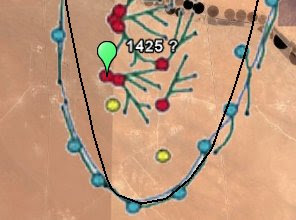 Its orientation and relative lateral positions suggests a good match with one of the southernmost Haradh III producers, as shown at right. Additional evidence comes from the well id (HRDH-1425). A complete synopsis of the well numbering scheme in Haradh will be forthcoming in a separate article, but for now I will just assert, based on evidence from the Saleri presentation mentioned above, that the 32 Haradh MRC producers have ID values from 1400-1431. I have also found a report of the drilling dates for to other Haradh producers: HRDH-1417 , from October 1 to November 17 of 2005, and HRDH-1406 from December 1, 2005 to January 3, 2006.
Actually, Just Getting Started
In summary, Google Earth is a useful tool for correlating the various fragments of information out there on Ghawar and other Saudi oil fields with what is actually found there by looking from above. In the midst of a lot of misinformation and sloppy reporting, it is hoped that this type of analysis can inject some independent and objective data into the discussion.



http://reddit.com/info/6af34/comments/ (science)
http://slashdot.org/firehose.pl?op=view&id=548470 (upmod on slashdot)
Thanks for your support.
Looks like you have it roughly where I had it.
I used the well locations image from the PhD thesis source and tied three old wells into Google Earth image to scale for Haradh. So that's an alternative.
I'm sure your familiar with the term a tease.
Please don't publish stuff like this to Peak Oil addicts without the follow up work.
The follow up piece will be called: "Satellite Sleuthing 102, Why the Cornucopian Theory Just Falls Down".
Price - $100,000
;-)
Oh, that's "rich!"
This could be a great resource. I wonder how it could document whats going on in Alberta - not that they are keeping secrets or such, but just to get sense of the scale vs environment, etc.
I have a few things that I have come across. But when the only things to really monitor are tree loss and maybe changes in the rivers, it's hard to get up the courage to look at it more than a few times.
No doubt. I've been to Mount St. Helen's and the destruction around the oil sands was very similar to what I saw at the volcano. I can't believe Canadians are allowing it. The pits of oil stained water are huge. I'd have to think the groundwater and streams flowing out of the area will be destroyed for centuries as this stuff leaks.
Haradh III is the bottom of the barrel.
let me rephrase that...300k barrels aint doin' squat. I don't care who you are. What was their decline rate for last year on their older projects? This bought us a month. Is that cause for celebration? maybe panic. My righteous indignation against this mentality is showing, I know, but how we can sit here and talk about Haradh III like everything is ok is beyond me.
I might as well ignore all of this and just watch the inventory reports to know when to get out of dodge.
I agree that 300k doesn't do much, and my point certainly isn't that things are rosy there. Yes, it has been hyped to death. But read this:
250 k/day. Wow. At least Saudi completed their project somewhat on time. If something causes you to get out of Dodge, that snippet above should be it. Or perhaps to at least get out of BP stock.
I am partly interested in it for clues to what is going on in a broader context. Their underlying message is "see, the latest technology helps get oil out of bad rock". Of course, the other way to interpret it is "all we have left is bad rock". They are currently working on Khurais, which ain't no north Ghawar either, and I am interested in parallels between the two developments.
A big problem is that we don't really know what the depletion rates of their older fields are. One possibility is to look at the number of new wells going in. Especially if these are MRC wells, and in the good rock of the north, the productivity should be high. If they put in 100 wells and each flow 5k/day, that is 500 kbarrels/day that those wells are replacing. What happens when they run out of real estate for new wells?
Well lets see if they can even find Thunder Horse later this fall.
LOST !!!
1 Multi Billion Dollar Oil Platform.
Last seen right before the Cat 5 Hurricane.
Responds to the name Thunder Horse.
If found please return to BP.
Thanks !
GWB.
Thunder horse: 250 k/day / 25 wells = 10 k/day/well
Haradh III (producers): 300 k/day / 31 wells = 9.7 k/day/well
Sometime after 90% water cut; oil wells became stripper wells that produce a few barrels a day for years. The United States has tens of thousands of these. How long will they maintain peak capacity of 12 million barrels a day of total liquids, if they reach it as scheduled in 2009? Insufficient data.
Can there be slowly seeping oil to a stripper well in an oilfield that has been washed thru by water flood? Stripper wells ought to be the end point of pre waterflood technolgy. But if you cap the wells and wait a few hundred years I guess there will be a redistribution of the oil in the wet field.
Will rust not be an issue in that time frame, or was that a sarcastic comment?
Try Oil Sands Truth: Shut down the Tar Sands. Your guided tour through the land of bitumen.
Is there any method to encourage Google to update imagery? Go just far enough north of here that I don't care and you can see the shadows from the tractors parked next to barns, but here our house and five outbuildings are just a white blur in the middle of a green smudge. Its frustrating ...
Go here:
http://earth.google.com/support/bin/request.py?problem=billing&extra.cus...
Oh, and while we're talking Google Earth, I rounded up a bunch of interesting points in the Persian Gulf a while back - air bases, naval facilities, oil and gas stuff, ports, etc. I've lost interest but anyone else is welcome to pick up the baton and compulsively map the area :-)
http://calculator.strandedwind.org/PERSIAN/persian-gulf-v4.kml
Did you find the Iraq Saudi Arabia Oil Pipline ?
It goes from Iraq to KSA, and Iraq can produce 1.5mbpd or so, which should explain the 2004 jump in KSA "exports"... right after US boots hit the ground. We all know which ministry the US taxpayer funded military was guarding.
Thanks.
As comic relief to this sobering, more detailed information on Saudi oil, there was an illuminating exchange between Bush and another person today. Someone told Bush that a gallon of gas may be as high as 4 dollars this Summer/Spring, and Bush was amazed that it was so high now. Reminded many of when Bush Sr. was so surprised when he saw a bar code scanner in a store and exclaimed that one day this wonderous device would be in all grocery stores. Of course that was 20 years after the fact.
So, let's get this straight. We have a President that until this person told him, had no idea whatsoever of the price of a gallon of gasoline. Hmm, why does that seem so unsettling? Why are these guys running the country so out of touch?!
In a faith based government, the decider-in-chief doesn't believe in facts. So who is going to waste the deciders time reciting them to him? There are decisions to be made!
Faith based - ah, yes, I think that was rejected by the Senate and imposed by the will of Executive Priviledge. Yet another dubious 'Decision'!