Storm Watch: Bonnie update, understanding wind fields
Posted by methaz on July 23, 2010 - 10:24am
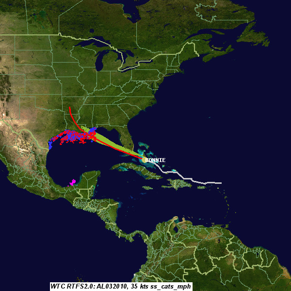
5pm ET Friday Update
Bonnie has passed over South Florida and is entering the Gulf of Mexico, pretty much on the forecast track. It has dropped below tropical storm strength, but should gain a bit over water to become a minimal tropical storm again. The post below pretty much sums things up: the main impact of the storm will be our reaction to it, since it is unlikely to cause much if any actual damage. There are often debates over storms like this, and accusations of "crying wolf". I certainly feel that we should be having those discussions, and worry about overwarning and the news media overreacting to weak storms. However, in this case, the problem is that we (the meteorological community) still do not have a lot of skill forecasting intensification of storms like this one, and if it does intensify, there wouldn't be time to react, especially for offshore assets like the Gulf of Mexico production and response rigs. It's a tough call.
Original Post
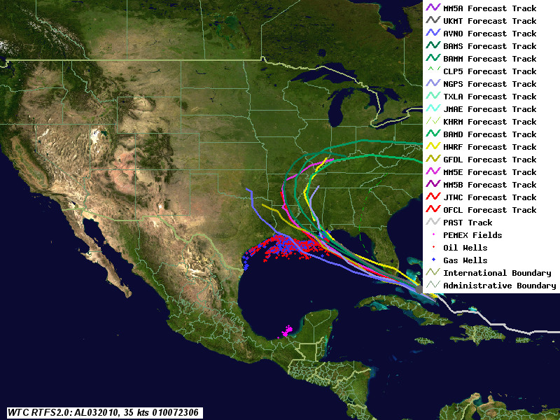
Tropical Storm Bonnie (AL03) continues to move through the Bahamas towards south Florida. It's not much of a storm at this point, just barely a tropical storm, and is not forecast to intensify very much. In fact, several models show it degenerating into a open wave (in other words, lose its closed circulation, one of the key characteristics of a tropical cyclone). Here's the current tracking map:
One important thing to remember about these storms is that, when the storm finally arrives, the area of peak winds is normally quite small. The reason why evacuations are needed over a wide area is in part because we cannot predict well in advance where that area will be. Also, as we have discussed earlier, there are things besides very high winds that can be damaging--for example, small boats have difficulty with big waves, and high tides can cause flooding.
Below I'll discuss the structure of wind fields, as well as potential impacts of this storm on both production and the oil spill.
Wind Fields
Here is the current Official forecast track from the National Hurricane Center, with the forecast wind swath:
That thin green band is the region of tropical storm force winds, assuming the storm follows precisely the forecast path. People often vastly overestimate the size of the damaging wind field from storms. The news media doesn't help, showing colorized IR satellite images that emphasize the cold cloud tops over the storm. The outer cloud shield for a hurricane or even tropical storm can extend hundreds of miles from the center. Yet even for an intense storm, hurricane force winds are normally confined to an area of less than 100 miles from the center.
Another issue is that tropical cyclone winds are reported as "over water" winds. While that's fine for oil rigs and ships, it overestimates inland winds by 10 to 30 percent. Normally, storms are asymmetric - the stronger winds are to the right of the direction of travel in the Northern Hemisphere. Thus, while Katrina was a Category 3 or weak 4 as it hit the Mississippi coast, on the "weak" site, the New Orleans area only suffered from Category 1 winds at the surface. (Scary thought, isn't it?)
Here is an analysis of Bonnie from the Hurricane Research Division:

As can be seen as a small blob to the upper left of the center (inside the bold line), the area of tropical storm force winds is extremely small, and in this case, not even in the usual NE quadrant of the storm.
Impact on production
We may see as much as a 60% shut in for a few days from this storm due to evacuations and precautionary shut ins, with full production restored by the end of the month. There should be no longer term impact - most of this area experienced the storms between 2004 and 2008, and should be able to hold up to a weak to moderate tropical storm with no significant damage.
Impact on the Spill
As discussed in this previous thread, we really don't know what will happen when a storm hits a large slick in an environment like the Gulf. As I've previously speculated, I suspect the benefits of mixing, dispersion, and rain flushing out the estuaries may outweigh the adverse impacts from a weak storm, but honestly we just don't know. Cleanup operations have already largely stopped. As the storm passes, booms and other protective barriers will be torn apart and thrown inland. In fact, if not removed before the storm, these booms and barriers have the potential to do a lot of damage to the marshes.
Subsurface Impacts
Hurricanes are a surface phenomena. Their impacts rarely extend more than a few hundred meters (600-900 feet or so) down the water column. In the continental shelf, where the water is relatively shallow, they can cause considerable havoc. At the depth of the Deepwater Horizon (DWH) well site (over 5000 feet), however, there will be no impact. The problem is for surface ships, and pipes connected to fixed subsurface structures. With waves over 20 feet, the up and down motion puts considerable stress on these components, meaning they are normally disconnected.
In shallower water (500 ft or less), strong bottom currents stir up sediments, sometimes triggering massive undersea landslides. These have destroyed pipelines from submersible production assets to shore in previous storms. However, the DWH site is far enough out this should not be an issue.
Tracking Resources
Here are a few links for hurricane tracking and wind information.
- National Hurricane Center
- NOAA real time weather and wave data from Thunder Horse complex, about 50 miles south of the Deepwater Horizon site
- South Florida WMD graphics, including model tracks
- CIMS/UW Tropical Cyclone Tracking Site
- Hurricane Research Division HWIND surface wind analysis
- Weather Underground Tropical Page.
- My experimental tracking page, with storm impacts and track model accuracy tables.
Contact
- Content: editors at theoildrum dot com
- Tech support: support at theoildrum dot com
License

This work is licensed under a Creative Commons Attribution-Share Alike 3.0 United States License.
Thanks for an excellent presentation. This does not look to be a deal buster for doing the bottom kill later next week.
According to forecasts, only slight intensification is expected from this storm. There seems to be considerable sheer from an upper level low pressure center that is moving to the west. NO deserves a break, so thank goodness we aren't looking at a much stronger cyclone.
Breezy and wet... could have been so much worse.
Craig
Very lucid, and otherwise helpful.
Thank you.
Somehow I never heard this level of detail in earth science in high school (about 50 yrs ago).
Could it be I just wasn't listening? ~;)
Lots of good info and images here
http://www.nrlmry.navy.mil/tc_pages/tc_home.html
NAOM
I'm in WPB. It passed south of us earlier today. We didn't get any wind and a little rain. It currently 120 miles due west, and a shower just started up.
That said, it should pick up some in the gulf before it gets to the DWH site. As with most of these storms they get more hype than anything else.
The rain from hurricanes has been demonstrated to carry single celled ocean organisms as far inland as Kansas in the past. Obviously such organisms did not evaporate into the clouds of the hurricane and had to have been picked up. Just as obviously, this means it is possible that hydrocarbons could be picked up and deposited much further inland.
Such an incident does not seem likely but it is definitely a possibility. If our government were being responsible, it would be monitoring rainfall from the time this storm makes landfall to determine if there are hydrocarbons present and if the levels are dangerous in any specific locale.
Unfortunately, I expect this administration to do what it does best, claim incompetence and defer to someone else who has a vested interest in any outcome other than the truth. They have done this on Wall Street, on the issue of health care, and so far have done so on the issue of the Deepwater Horizon Spill.
I hope and pray there are no bad side effects from this storm for the people of the Gulf Coast but if there are, they are likely to be reported by private individuals, not the US government nor the media which fawns over the Obama presidency.